
- The Basics of Boat Electronics
- Marine Radio basics
- Master the Boat Wiring Diagram 5 Ways: A priceless guide
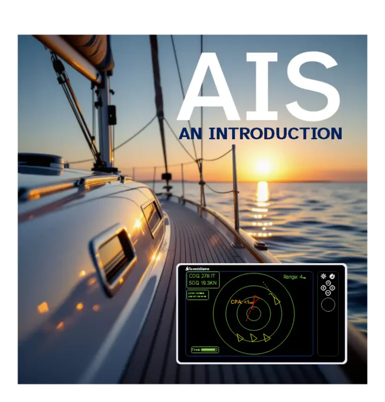
- AIS (Automatic Identification System) An Introduction and Practical Guide
- Installing a Bilge Pump
- Fuses for Boats – Fusing Marine Electrical and Electronic Systems
AIS Introduction: Demystifying AIS for New Boaters
Today, the Automatic Identification System (AIS) stands as a key technology in navigation and safety systems aboard vessels of all types. While mandatory for larger commercial vessels, AIS is increasingly affordable and accessible for recreational boaters.
This guide introduces boaters to the essentials of AIS, demystifying its operation, benefits, limitations, and practical integration with other onboard equipment. We’ll also explore how AIS data is displayed, the evolution of satellite and internet-based AIS, and how AIS supports search and rescue missions.
What Is AIS? – The Basics
AIS—the Automatic Identification System—is an automated, radio-based system that enables ships and shore stations to exchange essential navigational and identity information in near real-time. It was introduced by the International Maritime Organisation (IMO) as part of a broader safety-at-sea initiative and has become a crucial tool for collision avoidance and situational awareness on waterways worldwide.
AIS works by having ships equipped with an AIS transponder transmit data bursts over dedicated VHF radio frequencies (161.975 MHz and 162.025 MHz; known as channels 87B and 88B). Each vessel’s transponder periodically broadcasts information that includes:
- Vessel identity (such as name, call sign, Maritime Mobile Service Identity – MMSI)
- Position (latitude and longitude)
- Course and speed over ground
- Heading and navigational status
- Vessel type, size, draft (for larger vessels), cargo type (on Class A), and destination or ETA
The key idea is transparency—vessels effectively announce their presence and movement to others within VHF range, up to 20–30 nautical miles (NM), although terrain, antenna height, and conditions affect the range. This continuous, automated data sharing complements RADAR, as RADAR detects only the presence of objects but not who or what they are.
The primary aims of AIS are to:
- Prevent collisions by improving the visibility of vessel traffic
- Aid vessel tracking by authorities and other navigators
- Simplify vessel reporting, reducing reliance on voice radio
- Enhance search and rescue effectiveness
- Support safe, efficient navigation, even in complex or low-visibility environments
AIS also supports shore-based monitoring at ports and on coastal networks, and, via satellite, now extends visibility far beyond traditional radio horizons.
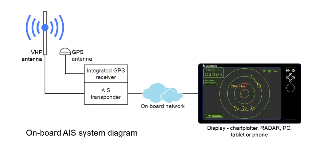
How AIS Works: Under the Hood
An AIS device (transponder) on a vessel receives GPS signals to determine its position, combines this with data about the vessel and voyage, and broadcasts a digital signal on two specific VHF channels. Other vessels and stations equipped with an AIS receiver (or a transceiver) pick up this information and use it to plot the position of these “targets” on navigational displays.
Technically, AIS uses a “self-organising time division multiple access” (SOTDMA) protocol for Class A transponders, allowing thousands of vessels to share the same radio frequencies without jamming each other. Each transponder claims a tiny “timeslot” in each minute-long broadcast cycle, dynamically adapting so that even in busy areas, essential data gets through.
AIS operates mainly in broadcast mode (every equipped vessel continuously sends info) but also supports selective transmissions for distress or special messages. While it is not a replacement for keeping a good lookout, AIS dramatically improves situational awareness, especially at night, in fog, and in high-traffic waters.
The AIS Family: Comparing Transponder Types
Overview of AIS Device Classes
AIS transponders are divided into several main types, tailored for different classes of vessel and application. The distinctions are important both for regulatory compliance and for choosing the right equipment for your boat.
| AIS Type | Intended For | TX Power | Update Rate | Data Transmitted | Key Features | Cost Range |
|---|---|---|---|---|---|---|
| Class A | SOLAS commercial vessels | 12.5 W | Every 2–10 sec (moving), 3 min (at anchor) | Full dynamic, static, voyage info | Mandatory for large vessels, full display, SOTDMA, text messaging | $$$$ |
| Class B (CS-TDMA) | Recreational & small commercial boats | 2 W | Every 30 sec (moving), 3 min (at anchor) | Limited data; no voyage details | Voluntary/optional, simpler, no text msg | $$–$$$ |
| Class B+ (SO-TDMA) | Larger recreational, high-performance boats | 5 W | Every ~15 sec | More frequent, reliable, some extra data | Enhanced version, faster updates | $$$ |
| AIS Receiver only | All vessel types, entry-level users | N/A (Rx only) | N/A | Receives data, does not transmit | No MMSI/membership needed, see others, not seen | $–$$ |
| AIS SART/EPIRB | Search and rescue | 1–5 W (varies) | On activation/emergency | Distress only | Portable or fixed; for MOB/SAR | $–$$$ |
| AIS AtoN | Markers/buoys | Varies | Every few min | Identity, position, status, etc. | For aids to navigation | N/A |
Table: Summary of AIS Transponder Types and Characteristics
Let’s break these down further.
Class A AIS Transponders
Class A units are the “gold standard” mandated for larger ships under international SOLAS regulations. Specifically, they are required on:
- All vessels ≥300 gross tons on international voyages
- Cargo ships ≥500 gross tons, not on international voyages
- All passenger vessels (of any size) engaged on international voyages
These transponders are high power (12.5 W), transmit comprehensive data, and update their position typically every 2–10 seconds underway (depending on speed and manoeuvring) or every 3 minutes at anchor. Class A equipment must be type-approved and comply with strict standards (IEC 61993-2). They also come with a dedicated display and can send/receive safety messages and text alerts. Class A devices use SOTDMA time-slot allocation, giving them transmission priority and reliability, especially in crowded waters.
Installation is an involved process—proper GPS and VHF antennas must be mounted with careful separation from other electronics for best performance. A reliable power supply and integration with navigation equipment are vital. Class A units are overkill for most recreational users but indispensable for commercial operations.
Class B and B+ AIS Transponders
For the average cruiser or small commercial vessel, Class B transponders offer a more affordable and accessible route to AIS capability. Designed for voluntary carriage (not mandated by SOLAS), these are perfect for yachts, sportfishers, smaller workboats, and others who want the safety and awareness benefits without the full commercial kit.
- Class B (CS-TDMA): Standard Class B units transmit at 2W, updating every 30 seconds underway (less frequent than Class A). They send less detailed information (typically omitting voyage/cargo details), cannot send text/Safety messages, and use CS-TDMA for time slots, which is less robust in high traffic. These are typically compact, easy to install, and can be integrated with plotters or run as standalones.
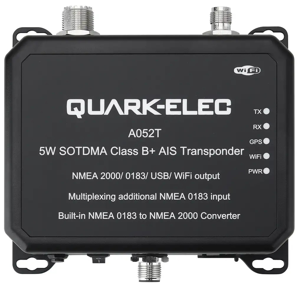
- Class B+ (SO-TDMA): Sometimes labelled “Class B SOTDMA” or “Class B+”, these newer units borrow SOTDMA technology from Class A, bumping up the transmission power to 5W and increasing update frequency (usually every 15 seconds, or faster for faster vessels). As a result, data transmission is more reliable, even in busy areas, and these units can get more “attention” from Class A-equipped commercial ships. Particularly suited for offshore, racing, or serious cruisers.
Choosing between Class B and B+ depends on your budget, the density of marine traffic where you operate, your need for visibility, and future-proofing your installation. Both allow you to “be seen” on other vessels’ AIS displays, enhancing your safety, but only Class B+ approaches the priority and update schedules of Class A.
Receive-Only AIS Devices
Budget-conscious or cautious about broadcasting your position? AIS receiver-only units allow you to receive and display all AIS broadcasts in your area, without transmitting your own vessel’s information. These are entry-level, highly affordable (sometimes under $300 USD), and involve simpler installation—often just a VHF antenna and a chartplotter or PC connection.
But there’s a key difference: With a receive-only device, you will see other vessels equipped with AIS, but they will NOT see you. In fog or at night, the big ships will not be alerted to your presence unless you have a transmitting transponder, so always keep your watchkeeping sharp.
Beginner tip: For offshore or busy harbours, investing in a full transponder is highly recommended, but if you’re just starting or want a quick safety upgrade, receive-only AIS is a worthwhile step-up from pure visual/RADAR lookout.
Internet-Based AIS and Satellite AIS
Beyond the classic “ship-to-ship” VHF zone, modern AIS data is shared around the globe thanks to shore-based receiver networks and satellites. Many mariners have encountered internet-based AIS services such as MarineTraffic, MyShipTracking and VesselFinder, which provide live or near-real-time maps of vessel movements powered by crowd-sourced and professional receiver networks.
- Internet-based AIS: Relies on shore stations (and increasingly volunteers running home receivers), aggregating AIS signals picked up on land. Services like MarineTraffic.com and MyShipTracking.com are invaluable for voyage planning, shipspotting, or fleet management. However, they are absolutely NOT a substitute for onboard navigation—the data you see online is delayed by minutes (sometimes even longer), and coverage can be patchy due to terrain or lack of sensors. Never navigate on the water relying solely on internet AIS—many vessels nearby might not be visible online, and there is a time lag that could prove dangerous for any real-time collision avoidance or decision-making.
- Satellite AIS (S-AIS): Satellites equipped with AIS receivers, such as those run by ExactEarth and ORBCOMM, continually monitor vessel traffic over remote oceans, polar regions, and beyond radio range of land. This data is used by commercial, government, and research clients to track global shipping patterns, improve environmental monitoring, and support SAR. S-AIS is less relevant for direct real-time navigation by small craft, but is transforming global marine domain awareness.
Key caution: Internet and satellite AIS make for fantastic “big picture” awareness, planning, and post-voyage analysis, but at the helm, your safety zone is determined by your own onboard chartplotters, displays, and real-time local signals.
How Is AIS Information Displayed? User Interfaces and Data Flow
AIS data, once received, can be displayed and used in several ways, shaping how you interact with other ships and aids on the water.
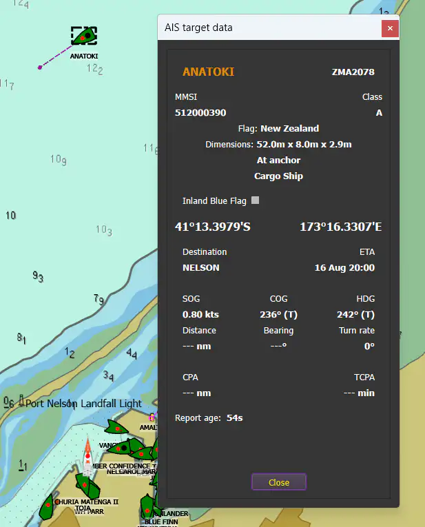
Typical symbols used on graphical displays
The graphic below shows examples of how AIS targets may be displayed on your chart plotter or chart plotter software. The shapes may vary a little; sometimes the symbols are colour-coded by the type of vessel: tug, tanker, ferry, fishing vessel, etc.. Some software distinguishes between class A, B, and B+ targets by shape or colour. Other displays allow you to set colours for friends or company fleets.
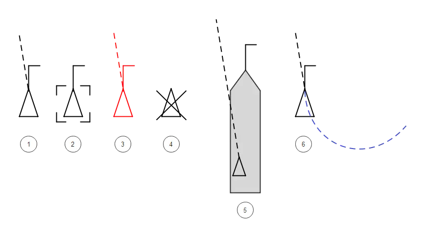
- Typical AIS vessel symbol: Dotted line shows predicted course over ground. The length varies depending on the vessel’s speed. The end of the line indicated the vessel’s predicted position after a set time period. The time period is set by the navigator depending on circumstances.
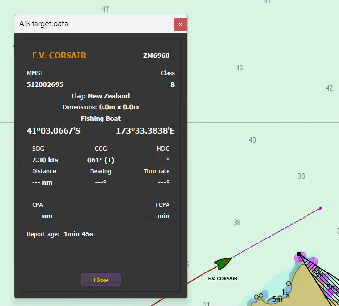
- AIS target selected by the operator: typically, a pop-up shows the vessel’s information.
- A dangerous target will typically turn red and flash with an audible alarm.
- Lost target – no transmissions have been received for several transmission cycles.
- The target is shown at the correct scale on the chart. The AIS icon is located at the location of the AIS’s GPS antenna.
- Target showing historical track.
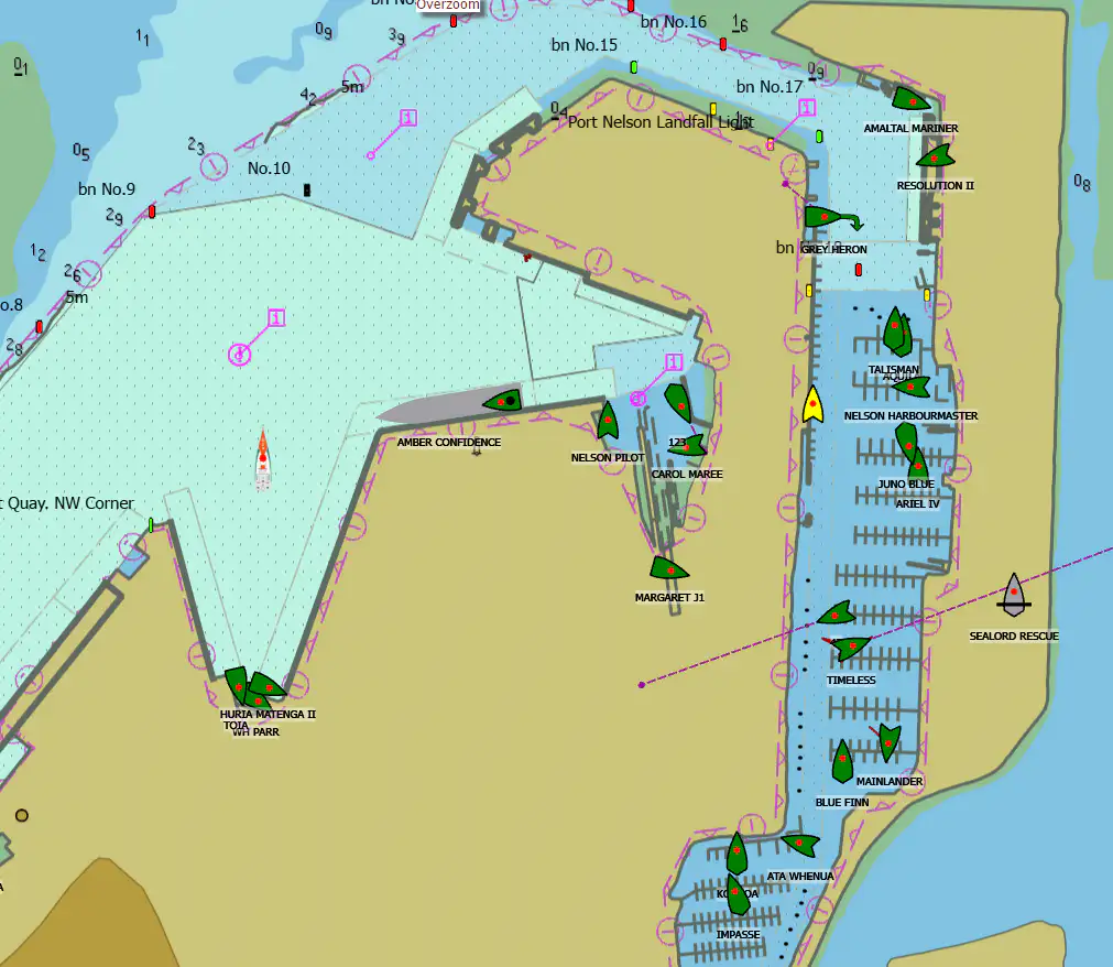
1. Chartplotters and Standalone AIS Displays
Most dedicated chartplotters and modern multi-function displays (MFDs), such as those from Raymarine, Garmin, Simrad, and others, allow for seamless AIS integration. When connected to a compatible AIS device, transmission and/or reception data is overlaid onto electronic nautical charts. Each AIS “target” is shown as a symbol, with selectable data about position, speed, bearings, and vessel identity.
Standalone displays (like the specialised Vesper Watchmate units) present AIS targets on their dedicated screens, with advanced collision prediction, audible alarms, and the ability to suppress non-dangerous targets for clarity.
2. Tablets, Phones, and PCs
Many AIS systems can output NMEA 0183 or NMEA 2000 data, which can be displayed on computers, tablets, or smartphones using apps like, QTVLM, OpenCPN, or on custom navigation or fleet management software. This is popular for flexible setups and offers extensive customisation, including alarms, logging, and even WiFi connectivity.
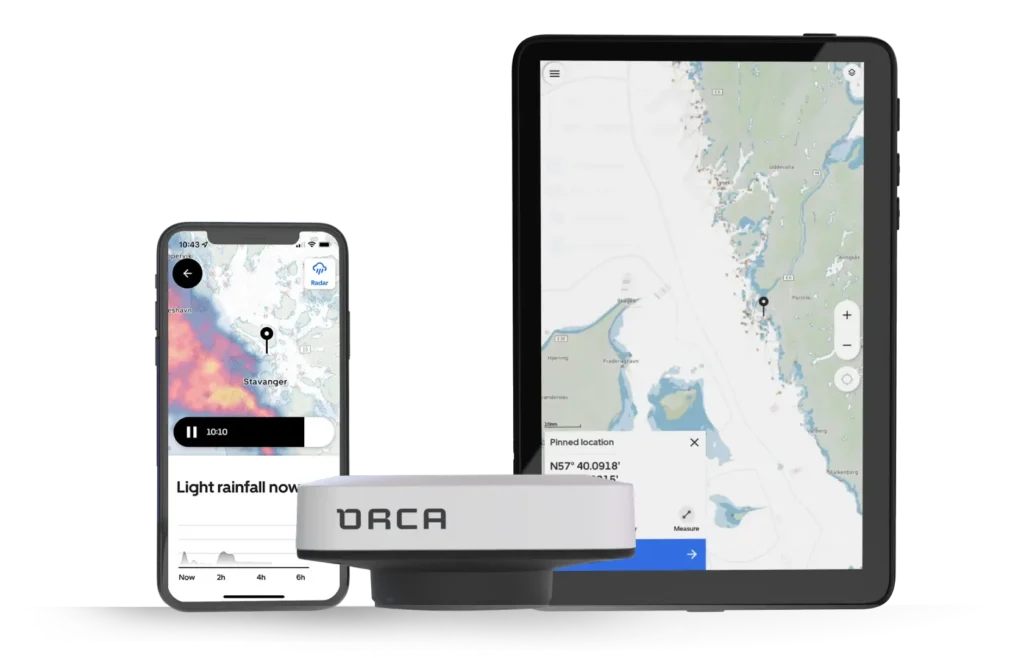
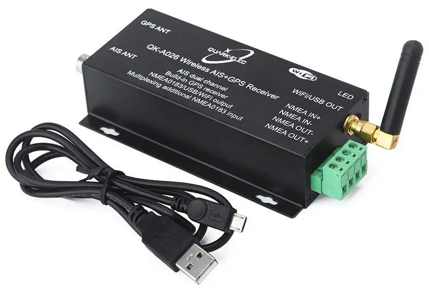
Companies such as ORCA and Quark-Elec provide a rugged tablets and a WiFi hub that streamlines setup. The ORCA system is particularly streamlined, whilst the Quark-Elec system is more suited to those on a budget and wanting to build their own systems using various modules.
3. VHF Radios with AIS Integration
Some modern marine VHF sets include integrated AIS receivers and basic target displays. These compact units display nearest ships on a simple screen and can trigger collision alarms, though the interface is less sophisticated than a full plotter.
4. Data Content: What Do You See?
Viewing an AIS target, you’ll be able to see:
- Ship’s name and call sign
- MMSI number (unique radio identity)
- Current position (lat/long)
- Speed over ground (SOG)
- Course over ground (COG)
- Heading (if available)
- Ship type, dimensions
- Navigational status (underway, at anchor, aground, etc.)
- Destination, ETA (if entered)
- Potential “closest point of approach” (CPA) and “time to CPA” warnings
All this data is broadcast in the open—meaning you can use it to avoid risks, hail other vessels by name or VHF direct call, and make informed navigation decisions.
AIS Installation and Integration: Getting Started
Planning Your Installation
Choosing and installing an AIS device involves several straightforward steps, each affecting performance:
- Device choice: Decide between Class A, Class B (CS or SOTDMA), or receive-only, based on your vessel, compliance needs, and safety preferences.
- Antenna placement: Install VHF antenna(s) as high as practical—masthead is ideal on yachts—to maximise range. AIS transponders can share a VHF antenna (using an AIS-certified splitter), or operate with their own. Signal clarity depends on minimising interference from other electronics and careful cable routing.
- GPS antenna: Class A and most Class B transponders need a dedicated GPS antenna, mounted with a clear sky view (not obscured by superstructure).
- Power: Ensure a stable 12V or 24V supply, with fusing and clean connections to avoid dropouts.
- Data connections: Link your AIS device to your chartplotter or network via NMEA 0183, NMEA 2000, or WiFi, according to your equipment. Some simpler receivers plug directly into a PC via USB.
- Programming: Assign the correct MMSI (from your radio license authority); this ID uniquely marks your vessel in the AIS network.
DIY installation is possible for many systems, but professional setup or electrical advice is always prudent, especially for Class A and SOTDMA units, or where integration with legacy systems is required.
Integration With Existing Equipment
Modern chartplotters and nav displays are often “AIS-ready,” requiring only the correct data input, while some VHF radios have integrated (or modular) AIS receivers. If upgrading an older setup, check for compatibility and available connections; sometimes a simple software update unlocks new features.
Dive deeper
Read more on in my article Marine Radio Basics
A word on splitters: If you plan to share your main VHF antenna for both voice radio and AIS, use a properly certified lossless electronic AIS/VHF splitter to prevent signal loss and protect your radio hardware; cheap or passive splitters can cause performance (or even safety) issues.
Advanced users may integrate AIS into a full electronic navigation environment—linking to autopilot, safety alarms, or even remote smartphone/tablet monitoring for extra comfort.
Dive deeper
Read more on networking marine electronics in my series on networking.
How AIS Data Supports Safe Navigation, Situational Awareness and Collision Avoidance
With AIS, you’re not sailing “blind” among a crowd of anonymous radar blips. Each nearby vessel equipped with AIS paints a clear digital presence on your display, complete with movement vectors and projected tracks. Many displays calculate and alert you to the Closest Point of Approach (CPA) and Time to CPA (TCPA), vital data for preemptively spotting and avoiding collision risks.
AIS vastly improves situational awareness, especially in:
- Night, fog, or low visibility—you know who is out there, how fast they’re moving, and where they’re headed. Commercial ships, tugs, and shore installations broadcast constantly, so even if you can’t see them or pick them up clearly on RADAR, you won’t be surprised.
- Congested waterways and ports—navigating in busy areas with ferries, harbour traffic, or large vessels becomes less stressful when you can “see” which vessels are on a collision course well before you see their lights or hear their horns.
AIS also enables direct communication: with the target’s name and MMSI, you can call them on VHF—by name or via Digital Selective Calling (DSC)—to clarify intentions, avoid misunderstandings, or cooperate on passing arrangements.
However, always remember: plenty of small boats, kayaks, and fishing vessels still lack AIS, so keep looking out and using all your senses and tools.
AIS vs RADAR: How Do They Work Together?
AIS and RADAR are complementary, not replacements for each other. Here’s how they differ and dovetail:
- RADAR detects all solid objects (boats, land, buoys, birds, even rain squalls), regardless of whether those objects are transmitting signals. It “sees” by bouncing microwaves and listening for echoes, giving you a true, real-time map of nearby (and non-cooperative) targets. However, RADAR can be affected by sea clutter (reflections from the faces of waves), rain, and needs setup/familiarity to interpret the display.
- AIS only displays other vessels (and certain aids) that are equipped and transmitting, showing not just position but name, course, and speed. AIS is not blocked by weather, but can miss small or non-equipped objects (logs, kayaks, small boats), and has only “line of sight” range.
When used together, you get the best of both: RADAR points out unmarked hazards, and AIS tells you the identity and track of all cooperating vessels. Most modern RADARs and chartplotters enable overlaid displays for a complete, actionable marine picture.
AIS Aids to Navigation (AtoN): Buoys and More in the Digital Age
AIS isn’t just for ships. Authorities now deploy AIS Aids to Navigation (AtoN)—digital “buoys” that broadcast their fixed or floating position (and sometimes health/status, metocean data, or warnings) as virtual AIS targets.
Types of AIS AtoN:
- Physical AIS AtoN: A transmitter installed directly on a buoy or beacon. These provide real-time, precise updates on their actual position, and can warn if the buoy drifts off station (e.g., after a storm).
- Virtual AIS AtoN: Broadcast by a remote AIS unit, marking a danger or navigation point where there is no physical structure present (e.g., temporary hazards, submerged wrecks).
- Synthetic AIS AtoN: A remote station broadcasts the AIS signal for a physical AtoN elsewhere, useful for remote or hard-to-access markers. Synthetic AtoN can be “monitored” (linked to the actual device for status) or “predicted” (position/status assumed but not confirmed).
These digital markers appear on modern chartplotters just like AIS-equipped vessels, with unique symbols and, often, extra information. They add a new layer of situational awareness, especially after extreme weather or in changing environments. This capability is invaluable for mariners relying on up-to-date information but unable to spot a damaged or missing floating aid with the naked eye. Here is a Quick guide to ENC symbols from the UK Admiralty explaining how these various virtual navigation marks may appear on chart plotters.
AIS in Search and Rescue (SAR): SARTs, EPIRBs, and Recovery
AIS’s value goes far beyond collision avoidance. In emergencies, it can be a literal lifesaver, supporting faster and more precise search and rescue (SAR) operations.
Key devices:
- AIS SART (Search and Rescue Transponder): AIS-based beacons that, when activated (e.g., after launching a lifeboat or in person-overboard situations), transmit location and “distress” messages across VHF frequencies. These appear as special distress targets on any AIS-enabled display in range, making recovery far faster and more targeted by directing rescuers straight to those in the water or adrift.
- EPIRB-AIS (Emergency Position Indicator Radio Beacons with AIS): Modern EPIRBs, required for many commercial vessels and increasingly adopted by serious cruisers, now often combine the traditional satellite-linked global distress beacon (406 MHz to the COSPAS-SARSAT system) with a local AIS distress signal. This means rescuers—whether local vessels, helicopters, or aircraft—get both a global alert and a precise local fix via AIS as they approach the search area..
AIS SAR devices are designed to be rugged, drift-resistant, and easy to spot on displays. For man overboard (MOB) scenarios, personal AIS beacons clipped to PFDs can automatically activate when submerged, dramatically increasing survival chances.
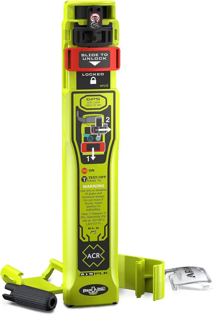
In my opinion personal AIS SARTs attached to a lifejacket offer the best chance of rescue for a MOB in an offshore context. Once the SART is activated, automatically or manually, any vessels in range will be immediately notified of the MOBs exact position providing the best chance of fast pickup. The RESQLINK AIS from ACR is a good example.
PLBs on the other hand broadcast to a satellite, which then downloads to a ground station, which then notifies a rescue coordination centre, which then alerts ships in the area and only ships with the correct communications facilites. All of this takes quite some time, perhaps too much time and doesn’t necessarily alert every vessel that could help.
Important note: Not all SAR beacons are AIS-based—for example, traditional EPIRBs and PLBs operate on different frequencies and protocols. AIS SART and AIS-EPIRB integration, however, represent the cutting edge for combined satellite and local digital rescue.
Regulatory and Classification Standards
The IMO, ITU, and other authorities set rigorous standards for AIS device performance, message structure, and installation. Transponders must comply with international conventions and technical specs (see ITU-R M.1371, IEC 61993-2 for Class A, IEC 62287 for Class B). National maritime authorities, such as Maritime New Zealand or AMSA in Australia, align with these protocols but add their own licensing and spectrum rules.
MMSI numbers—your vessel’s radio identity—are obtained from your radio licensing authority (in NZ: from the coastguard for small vessels). Proper configuration is essential: entering an incorrect MMSI or failing to program the device can make your boat “invisible” or cause confusion for authorities.
Be aware that AIS use is generally voluntary for recreational boats. However, continued improvements in technology, reductions in device cost, and best-practice recommendations for offshore/leisure boating mean more and more smaller boats are equipped each year.
Benefits and Limitations of AIS: A Balanced View
Benefits
- Automated and continuous: Once set up, AIS runs with no human input.
- Not weather dependent: Unlike RADAR, rain, fog, or spray do not disrupt AIS signals.
- Expanded coverage (with repeaters): Range can be extended via shore stations or satellites.
- Direct vessel identification: Know who is overtaking you or approaching in low-viz.
- Enhanced night safety: Silent vessels become visible, especially in busy anchorages.
- Search and rescue synergy: Quicker, more focused rescues with distress alerting and location.
Limitations
- Line-of-sight range: Usually 15–30NM; range depends on antenna height and obstacles.
- Not all vessels are equipped: Many small boats, older vessels, and some fishing boats don’t have AIS.
- Data input errors: Information is only as reliable as what’s entered—occasional typos, out-of-date destinations, or even deliberate spoofing are possible.
- Can be turned off: Vessels may (legally or otherwise) disable AIS for privacy or security reasons.
- Information overload: Busy junctions/harbors can result in dense, overwhelming displays; ensure you know how to filter for collision threats.
- Not a substitute for watchkeeping: Keep a proper lookout, always supplementing with RADAR, eyes, and ears.
The Risks of Relying on Internet-Based AIS for Navigation
Easy access to global AIS tracking via sites like MarineTraffic and MyShipTracking is a boon for ship-spotters, concerned families, and casual enthusiasts. However, it’s vital to understand the serious risks of trying to use internet-based AIS for navigation:
- Data delays: Internet feeds are delayed by several minutes by design; by the time you see a moving vessel, its real position could be hundreds of meters (or more) from what’s plotted.
- Spotty or missing coverage: In many remote areas, there are simply no ground receivers, so many vessels (including possibly the one heading towards you) don’t show up at all.
- Incomplete vessel presence: Small crafts, foreign vessels, or security-sensitive ships may not transmit or may use scrambled/incorrect data.
- Connection dependency: At sea, mobile and data links are unreliable—do not count on 4G or satellite broadband for real-time situational awareness.
Always use dedicated onboard AIS gear and navigation sensors—planning and peripheral awareness online is great, but on the water, only real-time, direct signals should inform your close-quarters or collision-avoidance decisions.
Practical Scenarios and Everyday Use
Let’s bring it down to the day-to-day. Here are practical examples of how AIS enhances your safety:
- Crossing shipping lanes: You’re approaching the mouth of a major port. On your chartplotter, you see a large cargo vessel moving fast to port—its AIS data tells you it’s travelling at 18 knots, bound for Singapore, and on a converging course. You can hail her by name to confirm intentions, alter course in good time, and avoid surprises.
- Night anchorages: It’s pitch dark; nearby yachts are visible on your display, letting you keep a respectful distance or check for late arrivals joining the anchorage.
- Foggy day at sea: Hearing a low bass horn ahead, you check your AIS—there’s a bulk carrier northbound, invisible in the mist but plotted perfectly on your screen, letting you plan a wide berth.
- Man overboard: A crewmember’s PFD is equipped with a personal AIS beacon—one press and your screen marks a flashing “distress” target, with precise location, for quick recovery.
- Spotting off-station buoys after storms: Authorities have marked a new hazard with a Virtual AIS AtoN—your plotter highlights the danger zone even before you would spot the unlit buoy or debris.
Conclusion: AIS as Your On-Water Ally
For today’s boater, from coastal cruisers to the farthest-range offshore sailors, AIS is a must-have technology to sharpen your situational awareness, boost your confidence, and keep you and your crew safer. While it doesn’t negate the need for vigilant watchkeeping, RADAR, charts, and good seamanship, it adds a uniquely powerful toolkit to the modern navigator’s arsenal.
From basic receive-only setups to state-of-the-art Class B+ transponders, there are options for every boat and budget. Integration with chartplotters and VHF radios is easier than ever, and the spread of AIS-equipped aids to navigation, SAR devices, and virtual buoys is enriching the marine safety landscape.
Remember: No electronic system replaces the human element. Use AIS as a potent supplement, stay observant, and enjoy your time afloat with trust in both your skills and your equipment. If you’re unsure where to start or want bespoke advice for your vessel, get in touch with TweedsMarine via the contact page.
Happy, safe boating!
FAQ
Frequently Asked Questions
What is AIS?
AIS (Automatic Identification System) is a radio-based system that automatically broadcasts vessel identity and navigation data (MMSI, position, course, speed, vessel type, etc.) over VHF so that nearby vessels and shore stations can see and track you. The information is typically displayed graphically, overlaid on electronic charts and RADAR.
Why should a recreational boater care about AIS?
AIS improves situational awareness, helps avoid collisions (by showing who is nearby and their course/speed), aids night/fog navigation, and supports search-and-rescue. It’s increasingly affordable and easy to integrate with chartplotters, tablets or phones.
What are the main AIS device classes, and which is right for me?
Class A: High-power, mandated for large commercial vessels; not necessary for most recreational boats.
Class B (CS-TDMA): Low-power (2 W), good for most recreational craft; voluntary.
Class B+ / SOTDMA: Higher power (~5 W) and faster updates — better visibility in busy/offshore waters.
Receive-only: Rx only (doesn’t transmit) — useful for seeing others, but won’t make you visible.
Choose based on where you operate (harbour vs offshore), budget, and whether you want to be seen by commercial traffic.
Do small boats need Class B+ AIS instead of Class B?
Class B is fine for many coastal and harbour users. Choose Class B+ if you sail offshore, race, operate at higher speeds, or want more reliable transmission in busy areas.
How far does AIS work?
AIS is line-of-sight VHF: typically 15–30 NM depending on antenna height, vessel height, terrain, and conditions. Satellites and shore stations extend coverage beyond VHF range for tracking purposes, not necessarily real-time navigation.
Where should I mount the AIS/VHF antenna and the GPS antenna?
Mount the VHF/AIS antenna as high as practical (masthead ideal) to maximise range. Conversely, the GPS antenna needs to be mounted in the lowest position that provides a clear view of the sky in all directions, away from obstructions and other electronics.
Can I share my VHF antenna between radio and AIS?
Yes, with a good quality electronic AIS/VHF splitter. Don’t use cheap, passive splitters — they can reduce performance or damage equipment.
How do I connect AIS to my chartplotter or phone?
Many units use NMEA 0183, NMEA 2000, USB, or Wi‑Fi. Check your devices’ compatibility and cabling options, and follow manufacturer instructions or get professional help for complex integrations.
What is an MMSI, and where do I get one?
MMSI (Maritime Mobile Service Identity) is a unique nine-digit radio ID for your vessel. Get it from your national radio licensing authority or coastguard (procedures vary by country).
What if I enter the wrong MMSI?
Incorrect MMSIs confuse other ships and authorities; fix errors immediately. Caution: You can only enter the MMSI number into your unit once (you enter it and then enter it again to confirm it), and if you get it wrong, the unit can only be reset by a dealer or the manufacturer.
Should I rely solely on AIS for collision avoidance?
No. AIS complements RADAR and visual lookout. Use CPA/TCPA alerts as guidance, verify with radar/visual bearings, and communicate by VHF if needed.
Can I use MarineTraffic or VesselFinder for navigation?
No. Internet-based AIS is useful for planning and high-level monitoring, but it is delayed, sometimes by 10s of minutes and may be very old (hours) and coverage is incomplete. Don’t use it for real-time collision avoidance at the helm.
What is Satellite AIS (S-AIS) used for?
S-AIS extends tracking over oceans for monitoring and fleet management. It’s great for big-picture awareness but not a substitute for local real-time VHF AIS while navigating.
What are AIS AtoN (Aids to Navigation)?
Aids that broadcast their identity/position via AIS: physical (on buoys), virtual (no physical structure), or synthetic (remote broadcasts). They appear on plotters and can mark hazards or off-station buoys.
How does AIS help search and rescue?
AIS SARTs and AIS-capable EPIRBs broadcast local distress targets that appear on nearby AIS displays, giving rescuers precise locations for faster recovery. Personal AIS beacons can be invaluable for MOB situations.
Can someone spoof or tamper with AIS data?
Yes—AIS messages are broadcast in the clear and can be spoofed or contain errors. Authorities and safety systems assume AIS is one source among many. Use vigilance and secondary confirmation methods.
Can I switch my AIS off for privacy?
A qualified Yes, Class B and B+ AIS can be turned off, although doing so reduces your visibility and safety. Larger vessels over 300 Tonnes and various commercial vessel types must transmit, although enforcement varies by region.
My display shows too many targets — how do I reduce clutter?
Use filters and alarm settings: filter by CPA/TCPA, range, vessel type, or suppress non-threatening targets. Many displays let you set noise/relevance thresholds.


One comment
[…] AIS target list, logbook, and pilot control pages […]